
Design with Precision
Capture every contour with detailed topographic surveys and 3D course modeling to guide accurate planning and construction.
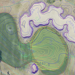
Green Complex and Sand Bunker Contouring
1 Inch or 3 Inch Green Topography with 3 Inch or 6 Inch Green Complex and Sand Bunker Topography using Robotic Total Station combined with RTK GPS Control.
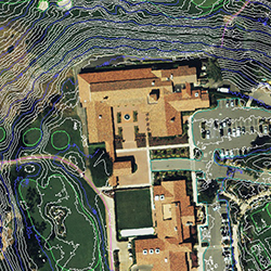
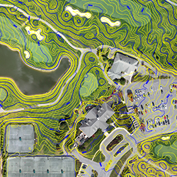
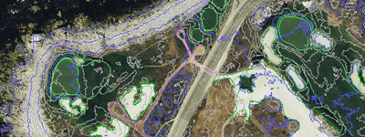
6 Inch or 1 Foot Course Topography
Overlay contour maps onto Aerial Photography with 1 Foot course contouring including all golf features, areas and basemap.
Core TOPOGRAPHIC Services
Comprehensive Site Surveys
High-precision topographic surveys providing detailed elevation data, contour mapping, and site analysis for golf course design and construction.
- Boundary Surveys
- Elevation Mapping
- Contour Generation
- Drainage Analysis
3D Modeling & Visualization
Advanced 3D terrain modeling and visualization services for course planning, presentation, and construction documentation.
- 3D Terrain Models
- Cut/Fill Analysis
- Visualization Renderings
- Slope Analysis
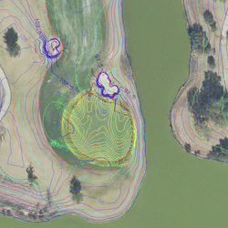
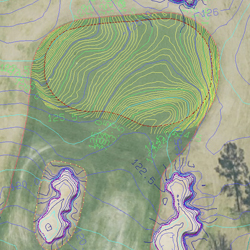
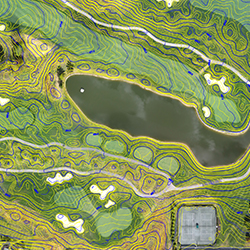
Green Scanning, Slope Maps, and Topo
Using state-of-the-art scanning technology and precision survey methods, GeoGolf delivers highly detailed green contour and slope maps that help superintendents, architects, and builders analyze, archive, or reconstruct putting surfaces with total accuracy. Every map provides measurable data on elevation and slope percentage to guide design and maintenance decisions.
1", 3", 6" Green Contours
Most accurate mapping methods and technologies to archive or re-build greens.
Slope Maps of Green Surface
Precise slope percentage maps with HD Photography of Green Complex.
Survey Technicians
On-Site Survey technicians trained in survey, mapping and geodesy.
AutoCAD Deliverables
AutoCAD file structure and drawings at any scale (Typically 1 inch = 5 feet) plus Green Slope Maps.
"We have worked with GeoGolf on several projects from 2008-2012 and they have consistently delivered the required products on time. Two notable projects include 400 acre topo of a new project site and an existing renovation that required 1-foot course contours, 6-inch bunker contours, and 1/10th foot green contours. We are very impressed with their work and will call them again."
Topographic Packages
Comprehensive survey solutions tailored to your needs and budget.
Topographic BASE Package
Essential Mapping & Design Foundation
Package Includes:
- Using Survey Grade GPS and Robotic Total Station for detailed 3D terrain model
- 6-inch contours of greens and greens complex areas
- 80% of USA covered in aerial photo database
- All area square footage / acreage calculations provided by hole, front/back 9 and Course totals
- Hole maps and routing provided for budgeting and design
- Data provided in AutoCAD format for Architect and Contractor use and integration
Topographic PLUS Package
Comprehensive 3D Mapping & Concept Design Suite
Package Includes:
- Survey Grade GPS and Robotic Total Station for detailed 3D terrain model
- 6-inch contours of greens and greens complex areas
- 80% of USA covered in aerial photo database
- All area square footage / acreage calculations provided by hole, front/back 9 and Course totals
- 3D concept plans of proposed course changes and routing
- High Resolution Printable Layered PDF files provided
Ready for Precision Surveying?
Contact us today for comprehensive topographic surveys and 3D modeling services for your golf course project.